


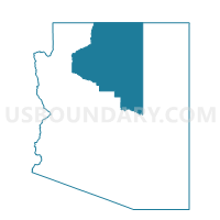
Cameron Voting District, Coconino County, Arizona
About
Outline

Summary
| Unique Area Identifier | 523743 |
| Name | Cameron Voting District |
| County | Coconino County |
| State | Arizona |
| Area (square miles) | 992.75 |
| Land Area (square miles) | 989.74 |
| Water Area (square miles) | 3.01 |
| % of Land Area | 99.70 |
| % of Water Area | 0.30 |
| Latitude of the Internal Point | 35.86944330 |
| Longtitude of the Internal Point | -111.59059550 |
Maps


Graphs
Select a template below for downloading or customizing gragh for Cameron Voting District, Coconino County, Arizona


Neighbors
Neighoring Voting District (by Name) Neighboring Voting District on the Map
- Bodaway Gap Voting District, Coconino County, AZ
- Coalmine Voting District, Coconino County, AZ
- Fernwood Voting District, Coconino County, AZ
- Fort Valley Voting District, Coconino County, AZ
- Grand Canyon Voting District, Coconino County, AZ
- Havasupai Voting District, Coconino County, AZ
- Leupp Voting District, Coconino County, AZ
- North Rim Voting District, Coconino County, AZ
- Pathway Voting District, Coconino County, AZ
- Tolani Lake West Voting District, Coconino County, AZ
- Tusayan Voting District, Coconino County, AZ
Top 10 Neighboring County Subdivision (by Population) Neighboring County Subdivision on the Map
- Flagstaff CCD, Coconino County, AZ (89,754)
- Tuba City CCD, Coconino County, AZ (31,639)
- Williams CCD, Coconino County, AZ (10,435)
- Kaibab Plateau CCD, Coconino County, AZ (2,037)
Top 10 Neighboring Place (by Population) Neighboring Place on the Map
Top 10 Neighboring Unified School District (by Population) Neighboring Unified School District on the Map
- Flagstaff Unified District, AZ (91,658)
- School District Not Defined, AZ (69,809)
- Tuba City Unified District, AZ (16,064)
- Fredonia-Moccasin Unified District, AZ (2,825)
- Grand Canyon Unified District, AZ (2,628)
Top 10 Neighboring State Legislative District Lower Chamber (by Population) Neighboring State Legislative District Lower Chamber on the Map
Top 10 Neighboring State Legislative District Upper Chamber (by Population) Neighboring State Legislative District Upper Chamber on the Map
Top 10 Neighboring 111th Congressional District (by Population) Neighboring 111th Congressional District on the Map
Top 10 Neighboring Census Tract (by Population) Neighboring Census Tract on the Map
- Census Tract 23, Coconino County, AZ (6,674)
- Census Tract 22, Coconino County, AZ (6,457)
- Census Tract 13.02, Coconino County, AZ (5,536)
- Census Tract 9450, Coconino County, AZ (4,180)
- Census Tract 9451, Coconino County, AZ (3,679)
- Census Tract 20, Coconino County, AZ (2,037)
Top 10 Neighboring 5-Digit ZIP Code Tabulation Area (by Population) Neighboring 5-Digit ZIP Code Tabulation Area on the Map
- 86001, AZ (40,776)
- 86004, AZ (37,338)
- 86045, AZ (11,354)
- 86046, AZ (6,090)
- 86023, AZ (2,627)
- 86020, AZ (1,941)
- 86435, AZ (487)
- 86036, AZ (388)
- 86016, AZ (62)
- 86052, AZ (28)